Clustering objects on the map
The service implements the ability to cluster objects. Objects that are close to each other on the map are combined into a group. A green circle appears on the map instead of object icons. The inside of the circle shows the number of objects that have been combined. When you click on this circle, the map scale changes so that all the combined objects become visible on the map. The color of the circle may vary depending on the number of objects that have been combined.
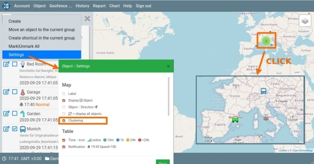
The clustering feature can be disabled. To do this, in the context menu of the object panel, click on the "Settings" element. A panel with settings will open. In the "Map" section, you need to mark (or uncheck) the "Clustering" element. When saving the settings, if the "Clustering" element has been changed, the page will be reloaded.
In addition to clustering objects, the service does clustering of POI items and events on objects tracks. When displaying a trace, event icons located close to each other on the map are also combined into a group and a green circle is displayed instead. When you click on it, the map scale is increased in such a way that all the event icons are visible. At the moment, there is no way to disable the clustering of event icons on tracks and POI items. When the service is improved, these options will be implemented.